This is the eleventh episode of my trips to visit as many of the fifty US States’ highest points. This time it’s a week in the inter-mountain west to bag Idaho and Nevada in August of 2020.
This trip was set up when my backpack on the John Muir Trail for July 2020 was canceled by COVID- 19. Mt. Whitney was to be the goal of that hike. This left me in shape but nowhere to go. I saw that no permits were needed for Idaho or Nevada, so I set this trip up as a replacement.
The trip started on August 18th with a flight to Salt Lake City, Utah from Little Rock. I rented a small SUV with the ground clearance I would need for access to Nevada’s high point and got the hiking supplies I would need to do my attempt of Borah Peak, Idaho on the 20th.
Flying during COVID was not too bad. You had to be aware of your surroundings and made sure you had stuff to eat on the plane as all they passed out was water and packaged snacks. The center seats were left open on the plane. Overall, I felt folks were really trying to stay safe.
Idaho
I spent the first night in Ogden Utah, where I took stock of my gear and set the SUV up to be my bedroom for the next night when I would get to the trail head campground for Borah Peak, Idaho.
After I got my supplies and breakfast at the local Walmart, I took a quick detour over to the Golden Spike National Monument. I had never been to Promontory before and thoroughly enjoyed the exhibit. The Highway Engineer in me was impressed with what was built with what they had.
After an hour or so I started the 275-mile trip north to the trail head near the town of Chilly, Idaho off US 93. I picked up a dinner before I made it to camp and decided to sleep outside the SUV as the weather was good that night.
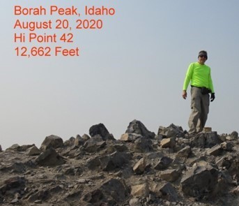
The hike up Borah, elevation 12,662 feet, is straight forward. You follow a ridge from the campground for about 4 miles to the top. The hardest part is the trail has a very steep gradient, 14%, for nearly the whole trip. You gain over 5200 feet as you hike.
The other obstacle along the way is a mile-long section called Chicken-Out Ridge. This ridge is only a hundred or so yards wide and has 1000-foot drop-offs on both sides. There was no real trail in this section either, so it took time to pick your way over to where the trail crossed a col that normally has snow on it, before you make an 1100-foot high climb over loose rock in the last ¾ of a mile.
I left camp at 5am, hiking by headlamp for about 90 minutes until daylight. I made it past Chicken-Out Ridge and had lunch about 12:30pm at the col. I realized that on my return I would have to clear Chicken before dark. But I was doing decent time and it looked like I should make it back to the car by dark at 9pm. Or so I thought.
It took me three hours to conquer the last ¾ mile. The trail was over loose rock and the steepness was taxing. Just before 4pm, I made it to the top of Borah to enjoy a smokey view of the center of Idaho. It had taken me 11 hours to go just short of 4 miles.
Because of all the loose rock, the slope, and the smoke, I kept my visit to the top short and headed back down. I had to clear Chicken-Out and get on regular trail before dark. I did make it through the tough spots in time and thought I’d stop for a bite as the sun set in a smokey orange haze. I still had two miles to go, I figured 9pm or 10pm back at the camp. Or so I thought.
At midnight, I was 17 hours into an 8-mile hike. Less than a half mile per hour. I couldn’t think straight, it was dark, I was sore, and I wasn’t sure if I was even on the right trail. I took my pack off and decided to take a nap before pushing on. I got some spotty sleep for the next 4 hours. The smoke cleared and I did get a great star show.
I thought I missed a turn to the trail head camp until I saw a group of hiker’s lights coming up the trail about 4am. I asked if they had come from the trail head camp or the other one. They said they had just cleared the trail head gate.
What!? Turns out I had stopped about 300 yards short of where my car was parked! Argh, I could have had a good sleep if I had just gone a few minutes more! I tossed everything in the car and took a nap until 8am. Borah Peak was on my list on August 20, 2020 as my 42nd state high point.
Nevada
This morning after that nap, I started a 450-mile travel day to get to Ely, Nevada for a stop before driving west across Nevada to Boundary Peak. There are two ways up Boundary Peak, elevation 13,147 feet, one following a creek drainage or the route I used from an old mine called Queen. Queen mine is about 7 miles off Hwy 6 on single track road that is subject to deep ruts.
A standard car can make it to a mine area at the 6-mile mark, but the last mile has a 1000-foot gain on that rutted road. If you don’t have a high-centered vehicle you’ll walk two extra miles as you have to walk a mile on the road to start and return. I had the clearance, but because of the sandy soil, my two-wheel drive vehicle could not get past a rut full of sand. This is where I found a wide spot in the road and made camp here. Since I didn’t get all the way up, I would have to walk about 1.25 miles more tomorrow. I organized my gear, had a snack, and hit the sack early for another long hiking day.
Sunday morning, I arose about 5am, got something to eat and started up the road to the trail head about 5:30am. Under the light from the headlamp, I started out a little slower than I wanted and it would be 6:30am before I made it to the trail head. A young man from California was loading up to hit the trail and we walked together until he pulled away as we climbed a ridge that would take us over to the base of Boundary Peak. The trail from the Queen to the base of the peak was about 3 miles, but it was well groomed and well laid out. I made it to the base about 9:30am.
The elevation gain from here was 2300 feet over about a mile-long trek to the peak. Unlike Borah, this rock was very loose and you lost elevation a lot looking for a foothold. I eventually found out that I should have been working the ridge area. I lost a good two hours trying various routes to make my way up the hill.
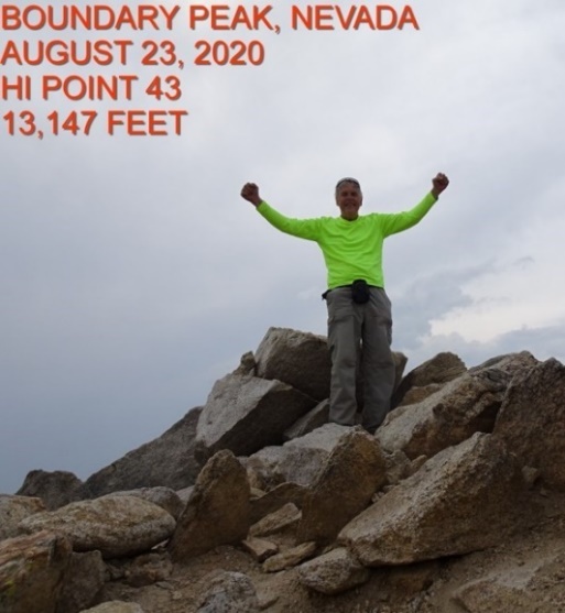
Once again, it would be nearly 4pm before I found myself on top. Nearly 6 hours to make it up a mile-long climb, so I was setting no speed records on this hike. I had hoped to spot Mono Lake, California from the top, but the smoke didn’t let me see beyond 20 miles or so.
Just a half mile away was the taller Montgomery Peak in California. The state line runs between the two, thus the name of Nevada’s Boundary Peak is obvious.
I signed the register and started down, hoping to make it to the good trail at the base of the mountain before dark. Turns out I did make it to the saddle about 7pm and ate some dinner. There was still almost 4 miles to get back to the car and then a 90-minute drive back to a hotel in Tonopah.
The walk back was on the good trail and road, but a lot of it was under headlamp since the sun went down about 7:30pm. It became another 16-hour hiking day as I got to the car about 9:30pm. I stored my gear, changed my shoes and started the drive to Tonopah.
Monday would be another long day drive back up US 6 to Ely, then US 93 and 93A to Windover, Utah and then I-80 into Salt Lake City, about 400 miles. Along the way I made a stop at the Bonneville Salt Flats outside of Windover. I got to the Salt Lake City hotel about dinner time, turned in my car and organized my luggage for the flight home on Tuesday morning.
I have started planning for next summer and you can join me on either or both trips. The exact dates are dependent on permits.
In Mid-June I am going to hike up Katahdin from Chimney Pond Camp at Baxter State Park in Maine. We will spend a few days there and then see some other trails in New England.
In early August, I will try to do the trip that was cancelled this year on the John Muir Trail. 42 miles over 7 days/6 nights. Mt. Whitney day hike is included on this trip.
Both trips have folks interested and more info will be coming soon.
Email me to let me know you’re interested Heye@aristotle.net