Here is the fifth in a series of my adventures to visit as many of the fifty US states’ highest points as I can. Last time we took a look at a trip from October of 2014 to
the southeast corner of the US: Florida, Alabama and Georgia. This time I will tell you of my tour of the Midwest following the Eclipse of August 21, 2017.
My wife, Meribeth, and I went up to my Aunt’s home in Sutton, Nebraska for the big eclipse. Her town was dead center on the path of totality. Nice! Following the event, we made our way towards the Minnesota State Fair in St. Paul. Along the way, one of our first stops was the highest point in Iowa. After the fair, Meribeth would fly home and I would continue bagging high points in the Midwest.
Iowa
Iowa’s high point, Hawkeye Point, is outside the town of Sibley. This is one of those easy ones: drive up, get out, take the photo. There is a patio and mosaic marker at the high point and it is surrounded by cornfields and a farmstead. Even at 1670 feet, it’s got a great view of the rolling hills of Northwest Iowa. There are also sign posts that point the way and distance to the other state high points. Iowa was my 28th high point on August 23, 2017. We got back in the car and drove on to Minneapolis.

Minnesota
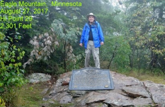
We spent the next few days at the Minnesota State Fair. This is one of the nation’s biggest, worth a trip on it’s own. On August 26, Meribeth flew back to Little Rock and I left for the Arrowhead of N.E. Minnesota, north of Duluth. The high point is Eagle Mountain and is on the edge of the area known as the Boundary Waters.
Michigan
To get to it, you drive along the shore of Lake Superior until you come to the town of Lutsen. You then take forest roads to a trail head that is about 3.5 miles from the 2301-foot summit. There is a small lake that you walk around and the mountain is just past the lake. Lots of wildlife, including moose, can be seen along the way. It was a misty day, but still a great hike. Lots to see in this area, I spent the night in a campground at a state park next to Superior. On August 27th, Minnesota was my 29th high point.
I left Minnesota’s Temperance River State Park early and made my way down to Duluth, then across the scenic shoreline of northern Wisconsin on my way to the Upper Peninsula of Michigan. By early afternoon I had made my way to the town of L’Anse.
The highest point is Mt. Arvon which is about 15 miles away. You are able to drive to the top of the mountain, but the network of forest roads is very confusing. It took me two runs at it even with a map and observing the signs pointing the way.
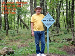
Finally, about three in the afternoon, I reached the parking lot on top of Arvon, 1,979 feet high. There is a sign and registry here and a bench nearby that lets you sit and enjoy the view of Lake Superior in the far distance. I returned to L’Anse and then made my way up to Houghton for the night. I was going to make a quick two day trip up to Isle Royal the next morning. Mt. Avron Michigan was my 30th high point on August 28th.
Wisconsin
I enjoyed everything about Isle Royal and hope to return for a longer stay the next time. I will also return by air, because I did not enjoy the return trip on the ferry to Copper Harbor, Mi. The lake was quite choppy and I had nothing with me for seasickness. I survived the crossing and started driving back to Houghton to recover.
The next morning, August 31st, I left Houghton going south to Timm’s Hill in central Wisconsin. I got to see a lot of the north woods of the Upper Peninsula and Northern Wisconsin along the way. Timm’s Hill is located 20 miles east of the town of
Tomahawk. At 1,952 feet, the hill is located in a county park. You park the car and take about a quarter mile walk up to an observation tower, marker and registry. The views from the tower allow you to see all the nearby farms and woods. By the time I returned to the car it was mid-afternoon and I still had to drive to Marshfield, Wisconsin. I was going to have dinner and spend the night at Margaret Bartelt’s home. Margaret and her late husband, Gordon, led trips for the Ozark Society for years when they lived in Arkansas. Timm’s hill was my 31st high point.

Illinois
Margaret was a wonderful host and we had a great time recalling all the outings we had been on together. It was Friday September 1st and this would be a travel day to Dubuque, Iowa, which is about 25 miles west of Illinois’ high point, Charles Mound. I stopped to see some of the sights along the way that I saw on a previous trip to the Wisconsin Dells and arrived in Dubuque about 3pm. Since I had some extra daylight left, I drove west to the Field of Dreams film site about 15 miles away.
The next morning, I would drive over to the town of Scales Mound, where the high point is located. Along the way is Galena, Illinois, home to General Grant. I stopped to see a few of the sights there.
Charles Mound, 1235 feet above sea level, is one of those high points that are located on private property. The mound lies in the center of a 4 square mile farm and is accessible on only four weekends each year. This is another reason I went to Isle Royal, to work my schedule out so I arrived on one of those weekends. The mound is about a mile from where you park and you walk up an old road towards the hill. You hike past cornfields and pastures to an old farmstead. From here you go up the hill and the marker. Also, up here, about 200 yards from the high point marker is the home for the landowner. They greeted people as they came up and signs said to respect the home area. The view was very good. You saw farms and woods in Northern Illinois and southern Wisconsin from the marker. Charles Mound was my 32nd high point.

I drove back to Little Rock by way of Hannibal, Missouri that afternoon and then made it home in time for Labor Day. I had driven over 1500 miles in 15 days, but I bagged 5 more high points. Next time I will tell the story of the Southern Appalachian high points with two trips that covered South Carolina, North Carolina, Kentucky, and Virginia.