This is the eighth in a series of my adventure to visit as many of the fifty US states’ highest points. Last time we looked at the odds and ends of high points I picked up as I went by. This time it’s a trip I took in September of 2018 to visit 7 New England states: Rhode Island, New Jersey, Connecticut, Massachusetts, Vermont, New York and Maine.
This was a very aggressive schedule, trying to get all 7 of these states in one 12 -day trip. The number of hikes that would require all day walking, the driving, scheduled stopping spots and weather all pushed me on this journey. It all started on Saturday September 22, 2018 when I flew to Providence, Rhode Island.
Rhode Island
This was my first time in Rhode Island. I would explore it more when I came back to fly home. I left my hotel and drove about an hour to the west center of this small state. Just off Rhode Island Hwy. 101, near Foster is Jerimoth Hill, 810 feet above sea level. You park at a sign on the roadside and walk about a quarter mile to the marker in a patch of woods next to a private home. Not much of view, but it’s a pleasant walk in a park-like setting.
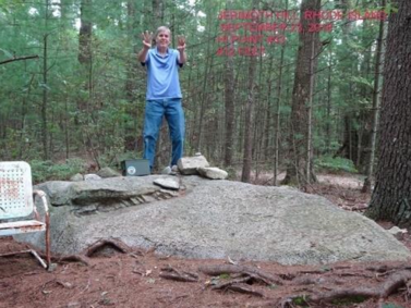
I took my photos and headed back to the car to continue my Sunday by going to New Jersey’s high point. On September 23rd, Rhode Island was my 33rd state high point.
New Jersey
To try and conquer this many states at once, I made up a route that would use my time most efficiently. This meant leaving western Rhode Island and driving across Connecticut, a part of New York to the Northern point of New Jersey.
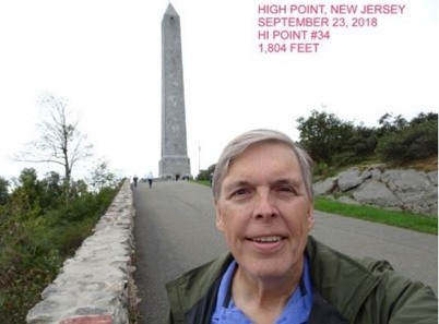
I mostly used I-84 to make my way to where New Jersey, New York and Pennsylvania all come together. A few miles south of this point is High Point State Park, New Jersey’s highest point. From the parking area, you walk up a paved road where the state has placed a tall monument on the summit. High point has an elevation of 1804 feet. One can climb the stone tower to get a view of three states, but the view from the base is just as good. It was now late in the afternoon and I had to drive back to Danbury, Connecticut to spend the night. On September 23rd, New Jersey was my 34th high point.
Connecticut
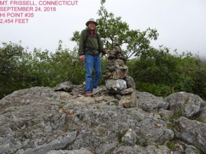
It was now day 3 of my circuit and it was to be just as busy as day one. I was going to drive this morning to the trail head for Connecticut’s high point and continue on to western Massachusetts to visit their high point before stopping for the night in Rutland, Vermont. I headed north out of Danbury to the town of Salisbury in Northwest Connecticut and started taking county roads towards the area where New York, Connecticut and Massachusetts come together. At the Massachusetts border is a trail head for the trail that will take you on a two mile walk to the top of Mt. Frissell Massachusetts. Wait? Massachusetts? Turns out the highest point in Connecticut is on the side of Mt. Frissell. A green state line marker on the trail stands in as the high point monument, 2,380 feet above sea level. As it was starting to drizzle and the wind was picking up, I returned to the car to continue my trip up to the state park that had Massachusetts’ high point. On September 24th, Connecticut became my 35th high point.
Massachusetts
I made it back to the car about 11am and headed north toward the town of Great Barrington, Massachusetts where I grabbed some lunch and then headed up US 7 to Lanesborough and the Mt. Greylock State Park. By mid-afternoon I reached the park only to find it shrouded in a cold mist and thick fog. I took the road up to the monument that the state has built on the high point. I imagine the view is a good one, but I could barely make out the tower due to the fog at that elevation of 3,489 feet above sea level. The monument is also, one of those on or near the Appalachian Trail.
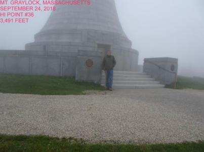
I made my way back down the mountain to US 7 and headed north to Rutland for the night. On September 24th, Massachusetts became my 36th high point.
Vermont
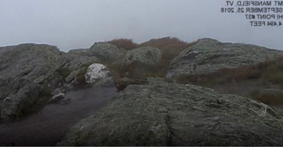
I was beginning to get confident in bagging high points in New England. Four in just two days. My cockiness would be tempered on day 4 of the journey. There was a front moving through the northeast today and I needed to get my hike in before it passed Mt. Mansfield. I got up early to make the drive from Rutland to Stowe and reach the entrance to the toll road that took you to a trail head on top of the ski resort. When I reached the top, a light rain was falling and the wind was around 10 mph. I still had a mile and a half walk out to the peak of Mt. Mansfield at 4,395 feet.
My walk would take me over a rocky, tundra terrain, exposed to the north face of the peak. As I made my way, the weather began to go downhill quickly. The front was early. The rain was now a cold heavy rain with sleet mixed in and the wind was up to 35 miles per hour and gusting to 45. My rain gear, though top notch, was being tested.
About an hour into my hike, staying vertical was becoming hard. I saw the trail going over the ridge where it split off the main trail and become a spur to the top. I was blown over by the much stronger wind on the south face. Gusts over 60 to 70 mph had me hugging the ground as I continued to try for the summit. I finally decided that I’d had enough, even though my goal was but 500 feet away. I took some photos and shot a video of the hurricane I was in, then spent the next hour trying to reach the calmer north face. I made it back about lunch time, nearly hypothermic and soaked when I reached the car. It was another hour before I was warm enough to start driving for my next peak, Mt. Marcy, New York. On September 25, 2018, I got really close to high point Vermont to count it. It was my 37th high point. I will go back and get the last 500 feet sometime in the near future.
New York
Having survived Mt. Mansfield, I drove all afternoon across Vermont and Northern New York to the Olympic City of Lake Placid. Outside the town, in the Adirondack Mountains is a lodge run by the Adirondack Mountain Club. The Loj at Lake Heart is a wonderful stay anytime you’re here. It has a variety of rooms and meals available on the edge of the wilderness. I spent September 26 in town as it rained all day. This gave me time to clean clothes, rest and see the Olympic sights. The hike to Marcy would be 14 miles and this day off was needed.
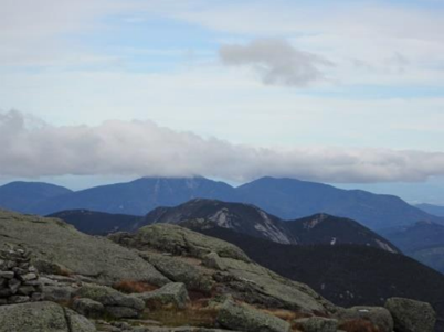
The next day I got up early, picked up my lunch made by the kitchen staff, ate a little breakfast and hit the trail. The first five miles were steady uphill trails walking in rocky, forested areas. The next two miles were in tundra and large boulders. It took about 8 hours to make it to the top. From the peak you could see the ski jumps in Lake Placid and the ski runs on White Face. I also wished I had a parasail to glide back to town.
It was almost 4 before I got going back to the Loj. Since it was past the fall equinox, it was getting dark by 7pm. At least it was light enough for me to get down on the forest trails before I had to pull out my headlamp. I had told the kitchen staff to hold my dinner as I would be late coming back. I hit the door at 9:30pm and even that late, there was my dinner waiting, warm and delicious. Those folks know how to spoil a guest.
On September 27th, New York was my 38th high point. This left Maine, Mt. Katahdin and the last of the New England peaks for me to get.
Maine
I was still sore on day 8 of the trip, but this would be an easy day driving the 350 miles from Lake Placid over to Baxter State Park. I had a lean-to reserved for two nights at a campground on the Appalachian Trail, 5 miles from the top of Katahdin. I picked up supplies in Bangor and made the park gate just as they were closing. I was in my bag by 10pm ready for an early start to reach my last peak. Everything was going as planned.
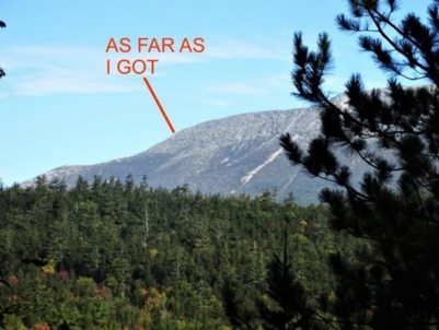
The next day, I had a ten-mile hike with a 4000-foot elevation gain and loss in front of me. The trail was the last 5 miles of the AT, so I thought it would be a well-planned and maintained tread. I left camp at 6:30am and feeling good, though my vision was starting to go double on me from my Lyme’s infection and fatigue.
The first two miles went slow, but steady. Lots of cobbles and roots on the trail, but not that bad. Over the next mile the steep climb began and you had to watch your hands and feet as you progressed over a constant boulder field. My double vision was affecting my depth perception and I had to slow down to less than a mile an hour.
The next couple of hours gave me some of the worst hiking I have ever done. There were hand and footholds to make your way up the route and nothing but sharp rocks to stand or grabbed to help. It was now 2 o’clock, my predetermined turn-around time. I had been walking 7 ½ hours and still had more than a mile and 1800 feet to go. Today was not going to be my day. With my sore body and bad vision, I had to turn around to get back to camp safely, before dark. This mountain won this round.
I returned to camp and had a late dinner and pondered my next move. I still had tomorrow to try again. If I get an earlier start, if I can pick up my pace. But the big “if” was my vision. With double vision cropping up, I didn’t feel safe climbing this way.
The next morning, I decided to pack it in and tour some other areas of Maine before I drove back to Providence for my flight. Katahdin could wait, besides I’m 38 and 1 on first attempts. I got 6 other high points. In all, the trip was productive. I will return some July, rested, when I have 17 hours of daylight, not 12. I can also go finish that last 500 feet on Mansfield, on a nice warm and dry day. I shall return!
If you are wondering where’s New Hampshire on this list, Meribeth and I visited the North East’s highest point, Mt. Washington 6,288 feet, in September of 2007. It was my 7th high point and so I bypassed it on this trip.
In Episode Nine we will look at the three points in the Western US: Utah, North Dakota and South Dakota that I visited in August of 2019.