When we think of geologic wonders in the Ozarks, they are most often associated with karst features like springs and caverns, lofty crags along bluff lines, and the historic legacy of lead-zinc mining. However, geoscientists also marvel over the one truly extensive midwestern exposure of the ancient (we are talking billions of years) exposure of the underlying crystalline “basement” rocks one normally associates with the glacially scoured Canadian Shield. Compare the ages of these rocks that predate the existence of anything more complex than simple bacteria with the “mere” 300-million-year age of the rocks that line the Springfield Plateau. The extensive area of these ancient rocks comprise the St Francois Mountains of southeastern Missouri celebrated by exhibits you can see in several state parks. Two of these are of special interest for geologically minded visitors: Elephant Rocks and Johnson Shut-Ins. Nearby you can visit a Civil War battle site overlooked by the ancient rocks of Pilot Knob and the igneous rock glades surrounding the highest point in Missouri.
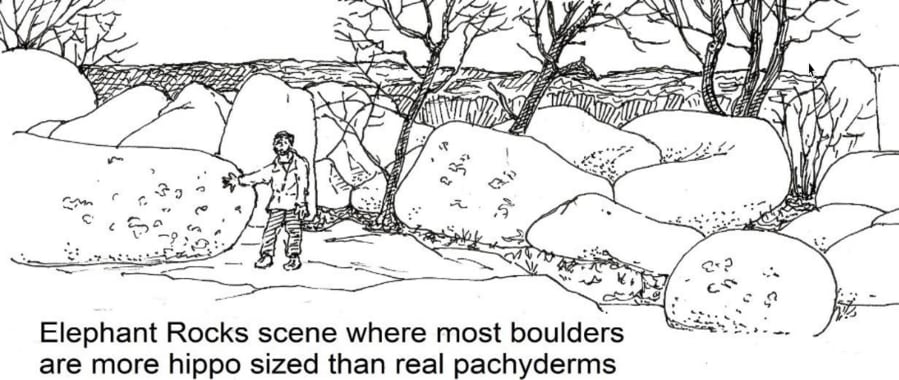
Elephant Rocks State Park contains a pink granite dome that exhibits the classic form of exfoliation where convex layers of rock separate from the central core as the weight of overlying rock is slowly eroded away. As this happens, a rectangular network of cracks (geologists call them joints) develops within the exfoliating layers. We see this exposed at the surface today. The elephant-sized boulders lying on top of the dome originated deep underground at a time the climate was much wetter and warmer. Tropical weathering then melted the outer edges of the granite blocks where they lay beneath the ground. In later times uplift eroded away the soil and soft outer layers of the once rectangular blocks so that the rounded cores of those boulders were left behind on the surface.
Many of these are simply great elliptic-shaped eggs, but a few more elongated boulders show the curved shape of the once continuous exfoliation layers. This is an unusual park where visitors are actually encouraged to climb on the most valued exhibits.
In addition to the scenic granite boulders that are the primary features of Elephant Rocks (see illustration above), visitors can see another interesting geological process. This is the production of a coarse kind of sandy gravel with the technical name of granite grus (pronounced with a Germanic-sounding “groose”). The granite here had congealed eons ago from a viscous mass of molten rock that became lodged at great depth. Because of the pressure and temperature at depth, the rock solidified very slowly, allowing the silica and feldspar crystals to grow to relatively large sizes – a quarter of an inch or more in diameter. The crystals interlock, giving the rock its strength. But exposure at the surface allows water to infiltrate along grain boundaries so that weathering rock sheds these large angular bits as the exposed surface crumbles.
Johnson Shut-Ins State Park celebrates the deep rocky canyon where a fork of the Black River funnels through a ridge of hard crystalline rock and is named after the original settlers on the property combined with the local name, “shut-ins,” for such tight and forbidding river constrictions. The tortuous nature of the rock fabric imposes a distinctly different structure on the eroded channel when compared to the “simple” layered bluffs of other Ozark rivers such as the Buffalo or the Meramec. Between deep pools the water divides to sluice its way through tortuous troughs carved within the swirling rock fabric. This is the kind of geology you might see at such places as the Great Falls on the Potomac where that river descends over similar ancient rocks at the piedmont fall line in Virginia. An elaborate series of walkways provide dramatic views of the canyon walls and rock-ribbed channels below.
The park waterway and its interesting rock formations would, by themselves, be of real interest to the visiting naturalist. But the park contains a world- famous geologic feature in addition that resulted from a dramatic reservoir failure releasing 1.3 billion gallons on December 14, 2005. A hydroelectric dam and reservoir downstream from the “shut-ins” park were augmented by a second reservoir built in 1963 on top of an adjacent mountain. This was a standard way to enhance hydroelectric output by allowing for generated electricity to pump water up into the upper storage area and have it released to provide extra capacity during peak usage hours. In this case a water level detector in the upper reservoir failed, causing the inflowing water to overtop one side of the containment embankment and flood down the mountain almost 2 miles to the main reservoir. There was waiting reservoir capacity below to contain the flood so that the only danger was to a park cabin where the four residents survived with minor injuries. The rushing water filled the “shut-ins” with great masses of tree and soil debris that were eventually cleared out so that the park could be restored. This was a disaster for the state park system but a boon for geologists who could examine a great swath of exposed bedrock free of overburden. At least one large national geological symposium featured a field trip to the Taum Sauk reservoir scour site. The Missouri State Geological Survey still posts a nice slide show explaining what you can see at the site, including a miniature example of elephant rocks in the making. The park today has a developed trail that leads you through the lower part of the bedrock exposure. In years to come this will be a useful research site where interested naturalists can monitor the slow process of succession on a newly exposed bedrock glade habitat.