Removal of obsolete dams to restore watersheds to their natural working conditions is a major topic these days in environmental news. Many of us think of such dams as local perturbations on a stream that act as sediment traps and impediments to the natural migration of aquatic life. Fine-grained silt particles in the sediment collecting behind the dam retain a potentially dangerous reservoir for fertilizer and pesticide chemicals washing in from fields and residences. But the situation is much more complicated than that because the function of streams as sediment transport systems depends on a delicate equilibrium that extends over the entire length of the watershed. You can see how this works by recognizing that the force moving sediment is given by the slope of the streambed. If a location has more force available than needed, the extra force will allow the water to eat away at the banks to create meander bends. This, in turn, effectively lengthens the channel to reduce the slope. If there is not enough slope to move the sediment, then gravel-bar deposits will build up producing a braided streambed with an increased slope and an increased sediment load capacity. Of course, the process is a lot more complicated than that. Much of a river’s sediment load is temporarily stored between high-water events, so the equilibrium is maintained only as averaged over decades of fluctuating flow rates. Yet it remains clear that a change to one single stretch of river can impact the entire watershed through the way that sediment is moved from headwaters to outlet along the integrated system.
One of the greatest dam removals of all time occurred in the 19th century in our midcontinent region. That was when army engineer Henry Shreve supervised a team removing the great raft of timber that blocked the middle section of the Red River in Louisiana starting in 1831. The intent was to allow routine navigation to reach cotton plantations being settled all along the river up into Arkansas and beyond. Grateful settlers named the city of Shreveport in Henry’s honor. They appreciated opening up the region to regular steamboat transport, but improved navigation was just one of many profound changes to the river that resulted from dam removal. We can document these changes because there are a pair of eyewitness reports on the pre-removal condition of the river from the leaders of the Freeman-Custis expedition sent to explore the Red River by President Jefferson in 1806.
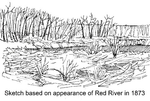
The expedition set out from the Mississippi in May and returned in September when confronted by a much larger armed Spanish force just above where the river now enters Arkansas. They reported a great raft of timber blocking the river for more than 100 miles, forcing the party to navigate through bayous and swamps on the northeast side of the river. My sketch is taken from a historic photo of a section of the raft that had re-developed before 1873 when TNT was used to open the river for good and gives a sense of what the original raft might have looked like. The 1806 report described the raft as a series of log jams hundreds of yards in extent, rising 2-3 feet above river level and extending all the way to the bottom of the channel. Shrubs and clumps of grass were growing on top of the logs and a horse could be ridden across in a few locations. But this was not a case of a person walking across the river and not even knowing it was there as reported in some descriptions. The Freeman-Custis reports describe moving their boats through a maze of narrow channels where chutes of fast-moving water ran through the trees alternating with large, shallow lakes studded with cypress and ash trees. The chutes were evidently transient waterways carved by the pent-up water behind the series of rafts, and the resulting current was a major challenge in moving the boats upstream in these confined channels. This is a far different environment than what we see in this part of the Red River valley today.
Once the timber dams were removed from the river there was a profound and permanent change in the entire ecosystem.
Freeman and Custis had reported vast wet prairies on the south side of the river studded with large lakes. With the raft removed, channels were incised into these prairies and the lush lakes dried up. The Great Swamp on the northeast side of the river completely disappeared. Texarkana historian Cole-Jett describes how the change in the landscape wrought by Shreve profoundly altered the way of life for those Caddoan natives still living in the valley. Deep bayous that had once provided access to shipping for cotton plantations located away from the river were no longer navigable. The river itself with its sediment load derived from arid Texas uplands could not be navigated during periods of low water. This great experiment presents an instructive example of the major changes – intended and unintended – that can be wrought by affecting a single section of a river or stream channel.
References:
- The Red River Valley in Arkansas – Gateway to the West, Robin Cole-Jett, 2014.
- Southern Counterpart to Lewis and Clark – The Freeman-Custis Expedition of 1806, Dan L Flores ed, 1984.