Welcome to the sixth in a series of my adventures to visit as many of the fifty US states’ highest points as I can. Last time we took a look at a trip of my tour of the Midwest following the Eclipse of August 21, 2017. This time its the southern Appalachians of the Southeast: North and South Carolina, Virginia and Kentucky.
On the first trip, my wife, Meribeth, and I went up I-40 to Ashville, North Carolina in October of 2010 to see Biltmore and the sights of the Smokies. The second was done in May of 2013 following the graduation of our nephew from Virginia Tech.
South Carolina
We used the town of Ashville, N.C. as our base to see the area. One day we went south of Ashville to visit the home and farm of Carl Sandburg, near Flat Rock, N.C., a stop we highly recommend. Before that however, we went just across the state line into South Carolina to see Sassafras Mt, 3560 feet, the highest point in the state.
At the time we visited in 2010, the access was a rough forest road to the radio towers on its summit. You parked your car about 200 yards short of the top and walked the rest of the road up to the site. Now they have made improvements to access for the site. The view is now a bit better with some clearing. You can now see Georgia, Tennessee and North Carolina from the top. We made our way back to Ashville for the night. Sassafras Mountain was my 10th high point, October 14, 2010.
North Carolina
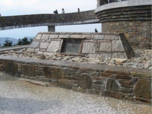
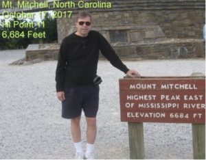
After seeing Biltmore and a few spots south of town, we spent a day driving on the Blue Ridge Parkway north of town. Along the way is Mt. Mitchell, the highest point on the east coast at 6,684 feet. This is one of those drive up, get out and take the picture high points.
We parked our car and made our way over to the structure that was built to take in the view. There are also trail heads starting here on the AT and one that goes to the Atlantic.
If you ever are driving along this stretch of the Blue Ridge Parkway, take time to stop at Mt. Mitchell and enjoy the view. On October 17, 2010, North Carolina was my 11th high point. We would visit Clingman’s Dome, Tennessee (my first high point) and Great Smoky Mt. National Park on our way home from Ashville.
Virginia
It would be a long two and a half years before I could continue my quest to visit high points in the US. Our nephew’s graduation from Virginia Tech in May of 2013 finally got me back into an area where I could visit a new high point. On the way home from Blacksburg, we made a stop in Abingdon, VA. so I could take a day to visit Mt. Rogers, the highest point in Virginia, 5729 feet.

Mt. Rogers is a short hike off the Appalachian Trail in southwest Virginia, just outside the boundary of Grayson Highlands State Park. This is an all-day hike should you take it on. The walk is about 9 miles total, all on the AT to doing an out and back. The state park is beautiful and is home to a herd of wild Shetland ponies. It was a foggy, misty day on my hike and to see a group of small horses on a hike was different.
After 3 hours of hiking on the AT, I passed a trail shelter and I spent some time eating lunch and talking with some thru hikers that were holed up there. Just past the shelter was the spur trail that takes you to the Mt. Rogers summit. Not much of a view from the top, lots of trees and rocks. I still had 4 miles to get back to the car, so I got my photos and started back. I made it back to our motel on I-81 about 6:30 in time for dinner with Meribeth. May 19, 2013 Mt. Rogers Virginia became my 12th high point
Kentucky
To get to the highest point in Kentucky, Black Mountain, we had to drive west from Abingdon, Va. over to Big Stone Gap, Virginia, on the Virginia – Kentucky line.
From here you drive up the ridge into Kentucky and not far is the forest road that will take you to Black Mountain. At 4139 feet high, the view from the summit is one you might not expect. This is another drive up, get out, take the photo high points. This also means it’s easy to get towers up here to take advantage of the terrain. Over our head was a communications tower and just off to the north was an FAA radar installation.
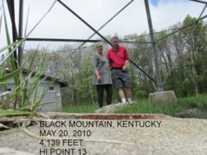
We drove back to Big Stone Gap for lunch and then headed southwest to Middlesboro, KY to see Cumberland Gap before heading back to Little Rock. Black Mountain Kentucky was my 13th high point on May 20, 2013.
Next time I’ll give a report on those high points that were ones that I did just because I was there for another reason or going by: Arizona, Delaware, Hawaii, Indiana and Ohio.