Global change will affect the Buffalo River and the surrounding ecosystem along with the rest of the world, but do we have to worry about that in our lifetime? The experts are quoting a temperature increase of a few degrees. How big a deal could that be? After all, we see daily temperature changes of several tens of degrees. Maybe we would hardly notice a degree or two difference.
Can we even expect to recognize that difference against the background of daily fluctuations? On the other hand, we know that greenhouse gasses have a major effect on how the planet absorbs heat, and that there has been a 40% increase in carbon dioxide in the atmosphere. That sounds like a big change. Are we going to see a real impact on the Buffalo River in the coming decade?
Let’s start with a couple of firmly established facts. First, it is obvious that the globe heats mostly at the equator and that the heat then moves down the temperature gradient towards the poles. That heat transfer occurs by turbulent mixing – a fancy way of saying that heat exchange occurs in the form of exchanging parcels of warm and cold air. That mixing of contrasting air masses is our weather. Second, it is an established fact that as the atmosphere has changed over time in the geologic past, the change was not uniform. An average change of one degree in the global data corresponds to only a third of a degree at the equator but three degrees at the poles. That’s why we hear so much about arctic warming and the disappearing winter ice cover. You can go online and search under Polar Amplification to learn about the subject. A pair of current Scientific American articles (March and June 2019) explain why that fact is so disconcerting and it involves a lot more than just a simple change in average world-wide temperature.
The atmospheric system is complex, but we can illustrate the problem with a simple analogy. Think of our weather system as propagating waves in the jet stream. The kinks in the jet stream give us the warm and cold fronts along with the weather those fronts generate. These waves were famously described by Swedish meteorologist Carl-Gustaf Rossby and named in his honor. A good analogy to the jet stream is a long bowstring under tension. If you pluck the string, the deformation propagates outward as a wave. Under high tension, the strong restoring force keeps the size of the deformation small and makes it propagate up and down the string at a brisk rate. Reduce the tension, and the deformation gets larger while the wave moves more slowly.
In the case of weather systems, the restoring force (the “tension”) is the temperature contrast. So, if the polar regions warm disproportionately, the excursions in the jet stream get bigger and move more slowly. That’s what brings us the polar vortex. With arctic warming reducing the “tension” on the Rossby-wave generating “bowstring” we expect more extreme and nearly stationary weather systems. As we suffered this spring’s repeated cold blasts Britain was burning up with wildfire and Switzerland was experiencing spring a month early. These are serious jet stream excursions.
A number of studies show the relationship between atmospheric Rossby waves and extreme weather excursions leading to heat waves and major floods. If you do the math, you find that the movement of Rossby waves is always upstream at a velocity that can be greater or lower than the wind speed. For small sized waves, the motion is with the wind and we see the usual progression of cold and warm fronts. For larger waves, the upstream velocity can come close to the wind speed, effectively stalling the progression of weather.
Topographic features help anchor these slowly moving jet stream excursions in place when they come close to stationary. This kind of condition was always possible in earlier centuries but becomes much more likely as the contrast in temperature between the arctic and mid-latitudes erodes under global warming. That erosion represents a net decrease in the resisting force (the tension in the bowstring) that can help push our weather out of a locked position. The Buffalo River and the Ozark region within which it lies must be especially susceptible to these quasi-stationary weather patterns because our region is located downwind of one of these topographic anchors in the form of the Rocky Mountain Front Range. With this introduction we can see how a little hard-core meteorology can provide some specific insight into what global warming can mean for us in the American heartland. This is not a simple question of temperatures increasing a degree or three within a weather pattern where daily differences of tens of degrees are entirely normal. It is not going to be the average temperature that will do us in. It’s the effect of the change of the major weather patterns that we have designed our civilized infrastructure around. If you wonder what global warming will look like for us in Arkansas, we have already seen it. We’re just going to see more of it in the future.

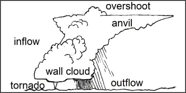
Structure of a typical severe frontal storm we can expect to see more of in the Ozarks under Global Warming.
