This is the ninth in a series of my adventures to visit as many of the fifty United States’ highest points as I can. In chapter eight we looked at the trip I took in September of 2018 to visit 7 New England states in one trip. This time we head out west to visit Utah, North Dakota and South Dakota in August of 2019.
It all starts on August 6th with a flight to Denver, picking up a rental car and driving to Rawlings, Wyoming, for the night. I would do all my prep work the next morning for my three-day backpack into the High Uintas Wilderness.
On August 7th, I drove over to Rock Springs and then spent a few hours exploring the Flaming Gorge region of the Green River before driving over to the trailhead for the night. In the morning I would load up and start my hike towards Kings Peak.
Utah
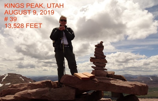
Located in northeastern Utah, Kings Peak at 13,528 feet is the highest point in Utah. It barely ekes out nearby points that make up the Uintas range. The range is not unlike the Ouachitas, as they run east-west, only they are way higher.
I had spent the night in the car, so when I got up, I checked my gear and began walking the 8 1⁄2 miles to Dollar Lake. This is where I would set up camp for the evening. You follow the Henry’s Fork River upstream as you hike in typical western forest and meadow terrain. I took my time and arrived late afternoon at the lake. I set my tent up and got things ready for the day hike in the morning that would take me to the top of the peak. I had dinner, enjoyed a beautiful sunset and went to bed early, as I had to leave by 6am to cover the 15-mile round trip to King’s Peak and back to camp.
I got up about 5:30, ate breakfast and started off for Gunsight Pass about 6. The route to the base of Kings Peak is quite circuitous. An unnamed peak and scree slope, that lay north and west of Kings keeps you from taking a more direct route. I am camped to the west of Kings, but I had to circle the unnamed peak and come in from the east side to reach the mountain’s base. This makes the round trip up to 5 miles longer. Gunsight was the first waypoint you had to go through to reach Kings.
One thing I hate is giving up elevation to get to a higher place. Having to give up what I gained to go over Gunsight was not an option, unfortunately. You drop into another drainage on the east side of Gunsight and walk over to the drainage coming from the north face of Kings. You follow this drainage up to a trail that will take you to the top of Kings Peak. I reached the base of Kings about 12:30pm and ate lunch. I also needed a rest after a 6-mile walk to get where I am.
About 1pm, I put my daypack back on and started scrambling up the 1,600-foot-high stack of large house- sized boulders that make up the mountain. The 1 1⁄2 mile long trail basically follows the ridge line. There are 3 false peaks on your way to the top and the last scramble is very vertical, a lot like the east side of Pinnacle Mountain. Nine hours and 20 minutes after I started, I made it to the top of Kings Peak at 3:20pm. Thoughts of Katahdin flashed in my mind as Kings was similar in structure and Katahdin was my last attempt at a high point. But this time I won! Or did I?
I took about 20 minutes on top and knew I had a long return walk coming, so I started back down all this granite while the sun was shining. You have to make sure of your footing. Any of the rock you are using is loose and it can be steep. My toes were constantly ramming themselves into rocks and fatigue didn’t help conditions either. It was two hours before I made the regular trail at the base of the peak.
I still had a 6-mile trip ahead of me, back over Gunsight and down to camp at Dollar Lake. My feet were also very sore from the hike so far and it was hard to keep a pace. Sunset was around 8:45pm that night and I made it to the Gunsight trail about then, but the pass was still more than a mile ahead of me. It was also time to get out the headlamp. Dinner was a small sandwich I ate while I walked on my totally trashed feet in the dark. And then the rain came. OH JOY! Whose idea was this trip anyway?
I crossed Gunsight about 10:45pm and still had almost 2 miles to go, but at least it was all downhill. I got back to my tent just past midnight, collapsed into my sleeping bag and slept well past sunrise. In the morning I packed everything up and headed down the trail slowly to the car parked 8 miles away.
The thought of a warm shower at a motel and a warm meal that night kept me going and I made it back to Rock Springs about 7pm that night. I was worse for wear, but on August 9 , Utah became my 39th high point. Time for a day of rest.
North Dakota
After a great night’s rest, I did some laundry and cleaned up my camping equipment and put it up. The remainder of my trip would be long car rides and day hikes throughout Wyoming, Montana, North Dakota, South Dakota, Nebraska and Colorado. I had rented a Toyota 4 Runner which would allow me to travel safely on to backcountry roads and haul all my gear. I spent most of this day, August 11th, exploring the historic Oregon Trail as I worked my way towards Sheridan, Wyoming, for the night.
I also made a stop at the world’s largest hot spring in Thermopolis, Wyoming. It’s free to the public and I was in need of a good soak. I came through the glorious Wind River Canyon to get to Thermopolis. This is a wonderful area to check out if you can.
Still on my way to make an attempt at North Dakota’s high point, the next day I left Sheridan and explored the Little Bighorn battlefield site in eastern Montana. I had been here as a kid and never really got to understand what all took place here.
By the time I was done, I was impressed by what had taken place over the couple of days of the battle. I left Little Bighorn and headed north for Custer, Montana, to catch I-94 east and my stop for the night, Medora, North Dakota.
My plan was to stay in Theodore Roosevelt National Park. The campgrounds were full here, so I got one at nearby Sully Creek State Park.
Medora is the town where young Teddy Roosevelt learned to be a cowboy, got inspired by the outdoors, and helped him become conservationist he was. The town has been rebuilt to resemble what it was like in the 1880’s when he was there. By the way, this part of North Dakota is far from being flat. Knolls, gullies, canyons, hills and other odd formations make up the area’s terrain. I got up the next morning for the 90- minute drive south to White Butte, North Dakota’s highest point at 3,506 feet above sea level.
White Butte is located about 6 miles north of Bowman, North Dakota, near US 85. You take a series of farm roads to reach the trail head. You leave your car and start walking about a mile along a fence row to a gate where the butte begins to rise from the surrounding flat farmland.
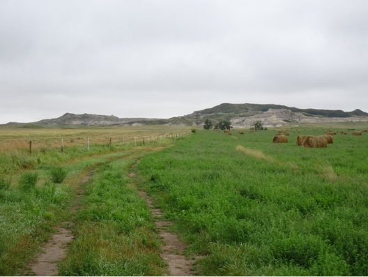
After another mile or so of climbing over eroded chert and clay, you reach the top. It’s a very easy trip. I passed a family walking in on my way back. The view is miles of nearby farms and a few other higher points of land like this one. It is privately owned, but the landowners have made this trail to keep folks in a controlled area and off the nearby farmland. On August 13, 2019, North Dakota was my 40th high point.
South Dakota
I made it back to my car after the hike up White Butte about 11am and started south on US 85 to the South Dakota Black Hills, home to Black Elk Peak. On the way I made a detour over to Devil’s Tower National Monument in northeast Wyoming. Always a pleasure to visit this site. I arrived at my hotel in Keystone, South Dakota, about 8 that night. It had been a long day on the road, so I passed on seeing Mt. Rushmore at night and hit the sack. I would see it in the morning on my drive over to nearby Black Elk Peak.
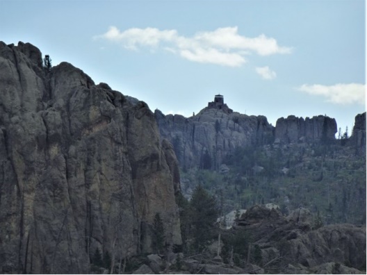
Black Elk Peak, or Harney Peak as it was previously called, is about 6 miles to the southwest of Mt. Rushmore. It’s in the Custer State Park and has a well-developed trail to the top of the peak, 7,242 feet above sea level. The hike is about 8 miles total and takes a couple of hours each way. At the top is a Forest Service lookout tower that is a joy to explore. I had lunch on top and noticed the afternoon storms were moving in. On August 14 , South Dakota was my 41 high point.
I continued that day exploring the rest of Custer State Park and headed south to Sidney, Nebraska, for the night. Along the way I saw Wind Cave National Park, Carhenge in Alliance, Nebraska, and caught a distant view of Chimney Rock on the Oregon Trail. From Sidney I would leave for Denver and a plane for home.
In Episode Ten we will look at the three points in the Appalachians that I did back in 2017: West Virginia, Maryland and Pennsylvania.