This is the Twelfth episode of my trips to visit as many of the fifty US States’ highest points. In chapter eleven we looked at the trip I took in August of 2020 to Idaho and Nevada. This time it’s a coast-to-coast endeavor to bag Maine and California in the summer of 2021.
The goal for this year was to make a second run at Katahdin, Maine and then six weeks later to backpack on the John Muir Trail with Mt. Whitney, California as the highlight of that hike. Both trips were advertised as trips for the Ozark Society and required a lot of permit applications and logistics to pull them off. There was also a lot of physical conditioning required as both peaks would present challenges. By mid-May, most of the planning and prep had been done, so it was time to concentrate on trip one, Katahdin, in the Baxter State Park of Maine.
Maine
In Episode Eight I recalled my trip to the North Eastern states in September 2018. Among the peaks I attempted was Katahdin, Maine. It was a tough hike and I had to turn back because I ran out of time to make it safely to the top and back before it got dark. For my second attempt, I scheduled the hike on one of the longest daylight days of the year, June 16th which had nearly 18 hours of daylight to use.
I attempted to get some Ozark Society members to accompany me on the trip, but no one could make their schedule fit the days my Baxter State Park permits were good for use. I flew to Boston on June 11th and rented a car to visit not only Maine, but two other state high points to use as warm up hikes for Katahdin.
On Saturday morning, June 12, 2021, I began my quest by driving west on the Mass Turnpike to Great Barrington, Massachusetts. I was on my way to re-hike the Connecticut high point located just southwest of town. I grabbed lunch and drove to the trail head for Mt. Frissell. The first time here, I could not find the state line marker that denotes the highest point in Connecticut. This time the conditions were much better than the cold rain of 2018, sunny and mild. After ninety minutes or so I reached the top of Frissell, which is in Massachusetts. From there I had to take a trail leading to the Tri-state point for New York, Massachusetts and Connecticut. About ten minutes down the trail I found the marker that represents the highest point, a green colored survey pin for the state line. I took my photos and enjoyed a great view. A couple hours later I was on my way north on US 7 to a lean-to at a campground in southern Vermont for tomorrow’s warm up hike.
Sunday’s warm up hike would be on Mt. Mansfield, Vermont, home of the Stowe ski resort. I was left a few hundred feet short of the top of Mansfield on my first attempt in 2018. High winds kept me from the summit that day. Today was much calmer and warmer. I drove the access road to the top of the ski runs and hiked the three miles over and back to the high point. Once on top you could see three other state high points from Mansfield: Marcy in New York, Greylock in Massachusetts and Washington in New Hampshire. The Mt. Washington area is where I was headed next, to do some hiking around Pinkham Notch on Monday. I went back down to Stowe for lunch and hit the road east.
After another night in a lean-to at Moose Brook State Park, I did a couple miles at Pinkham Notch on the east slopes of Mt. Washington. From here I drove down to Conway, N. H. to the REI store. Somehow, I had forgotten to get my boots into my bag before I left. I found a pair of Merrill MOABs that would be perfect for my hike in Maine. I drove over to Bangor to get the last of the supplies I would need to do the three-day backpack trip at Baxter State Park.
I drove up to Millinocket the morning of June 15th and on to Roaring Brook campground in Baxter State Park. From here I would backpack that afternoon up to yet another lean-to at Chimney Pond, on the east side of Katahdin. I set up camp and went to bed early for my day hike to the top of the mountain, two miles away.
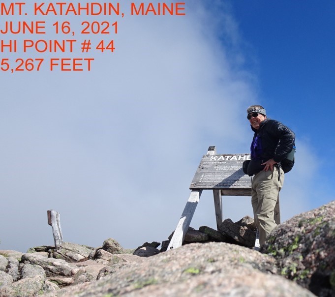
I got up at sunrise, ate breakfast and started up the Saddle Trail from Chimney Pond about 6 am. The climb is steep and rocky, up a valley and col on the side of the peak. The first mile you gain over 1000′ to top out onto the Tablelands. This is a sloped plain on the mountain’s flank that takes you the rest of the way to the top. The walk over the Tablelands, though not as steep as the first mile, is still very rocky. I was glad I had my new boots and not the tennis shoes I used on the warm up hikes.
At 9:30 I finally reached the famous sign proclaiming the summit and the northern terminus of the Appalachian Trail. I had the place to myself for about five minutes and enjoyed the solitude. On June 16, 2021, Mt. Katahdin became my 44th state high point, 5,267 feet. The weather was starting to degrade, so I left all those celebrating on top and descended back to Chimney Pond for the day. The next day I would hike out to Roaring Brook and drive on to Boston for a flight home.
It was now six weeks until I would be joining seven others on my quest to visit the John Muir Trail and Mt. Whitney. I was pleased with the conditioning I had done and felt no ill effects from the Katahdin trip. In fact, I was optimistic. I was going to have a great outing, since my pack was going to be as light as I had ever carried on any other backpack trips. Less than 40 pounds. It could have been 100, it didn’t matter. A tick in my back yard had other plans for me, something I did not see coming.
California
I was counting the days leading up to the second hike and doing the prep work to my home and yard so I could spend two weeks on the road. One thing I did was to take advantage of lower temps in early July to clean up the downed wood and yard trash to burn it. This included a dead tree and it has to be when I was bitten by a tick and, unbeknownst to me, infected with Rocky Mountain Spotted Fever.
A couple of weeks before I left for the west, I was getting gut pains and headaches. I should have checked with my doctor then. I did get a Covid test and that came up negative. I put it off to pre-trip jitters. I also didn’t want to throw a last-minute delay in the trip for the others. I was responsible for several pieces of the trip.
I had advertised the John Muir Hike since November and had several folks express interest. With the help of Brian Thompson, we managed to procure nine permits for our group to hike the trail and visit Mt. Whitney. We made campground reservations for two nights at the trail head, Onion Valley. The campground had an elevation of 9200 feet and would help us acclimatize before we hit the trail.
By May, our group had been set at eight participants. All of us had been training since Christmas and we all had experience at long distance backpacking in mountainous terrain. We had five Ozark Society members: Brian, Tim Mason, Ellis Gregory, Bob Ordeneaux and myself. The other three were friends we knew: Ron Dumoff and Steve Pruett from the San Diego area and John Collins from Dunlap, Tennessee.
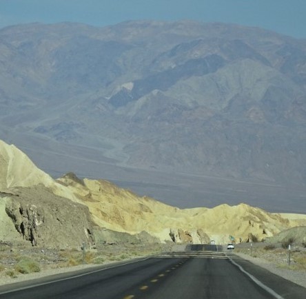
Brian, Ellis and I rented a car and drove out. We made a side trip to Death Valley on our way to Lone Pine, California. None of us had been there before and found the place to be utterly unreal. We met up with the rest at Onion Valley on Wednesday, July 28th with all our permits in hand.
We spent the next two days getting used to the altitude, shuttling cars and picking up last minute items for the hike. I was still not firing on all cylinders, in fact we had stopped a couple days earlier in Flagstaff, Arizona to see why I still had a gut pain. Nothing was diagnosed by the Doc in the Box, so I carried on with all the pre-hike activity and got ready to go on the morning of Friday, July 30th.
Since everyone was experienced, we drifted out of camp and up the trail to Kearsarge Pass when we were ready. I hit the trail early and was moving quite well with a light pack and very well laid out trail. Compared to Maine, this trail was a freeway to me. But as I continued throughout the morning, I was not hiking as fast as I should have been.
I was not winded and my muscles felt strong. Something was not right, however. All my joints were hurting and I had to stop with the weight off my back to regain my strength.
As time went on, those who had started behind me began to pass me. My stride was becoming forced. My nerves were keeping me from walking with a steady gate and I kept having to stop to let things catch up. About one o’clock a storm was brewing over the pass and I knew this would be a couple hour wait. I set up a shelter and sat down to wait it out. I had some lunch and had a lot of time to think things over.
Everyone had passed me by lunch, but I received word from other hikers that a couple of the guys would wait for me at the pass, still two miles ahead of me. That was another problem, I had only gone 3 miles in 6 ½ hours. Even that is unusually slow for me. I still was feeling a bit tight in the gut and the joint and nerve pain was bothering me from a safety standpoint. As the rain was ending, I realized that my attempt to hike the trail would be ending too. I decided to call it. For the first time in my hiking career, I would turn around and return to the campground. I sent word up trail to those waiting for me at the pass to go on, loaded up and headed back to town. I would make it to Lone Pine that night about 8:30 thanks to two rides, then spent a couple days at the Mt. Whitney Motel, our unofficial headquarters, recovering.
The next day while resting, I retrieved our rental car from Whitney Portal. At least I had transportation. I wish Ron had left his key at Onion Valley, I could have driven his car back to Whitney Portal and had that shuttle out of the way for next week. Later that day, I heard a knock on my door. There was Bob Ordeneaux! He too, had turned around after spending the night on the other side of the pass. He decided his conditioning was not good enough for some of the tougher sections ahead of him. The next day we retrieved his truck from Whitney Portal as well.
After two days, I realized I could still do things using the car. I had to stay out of the heat and limit my hiking. Since I had never seen Yosemite before, I took the next three days of waiting for the backpackers by driving over the Sierras to see it. It was well worth the trip. I also checked out Manzanar Internment Camp, Mono Lake and several other places north of Lone Pine. I made it back in time to pick up a couple of the guys who came out a day early at Whitney Portal. On Thursday, August 5th, the remaining three hikers came out after completing the schedule I had laid out. We all gathered up gear, vehicles and said our goodbyes as we started back home. I will let Brian relate the story of those who completed the planned hike in a story by him.
Brian, Ellis and I made it back to Arkansas on Saturday night. I was glad to be back home, but I still had my headaches and gut pains. It took a week for me to get in to see the doctor, but he ran his tests and confirmed I had a tick-borne illness. It’s been a couple of weeks of antibiotics and I am finally starting to feel better. I guess ticks and me just don’t see eye to eye. Two bouts of RMSF and Lyme would tend to keep one out of the woods. Don’t count on it ticks! I didn’t make it to Whitney this time, but there is always next year. So I’m stuck on 44 high points for now and planning ahead for maybe more.