By Perry Hill, Bayou Chapter Ozark Society
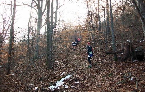
The Athens-Big Fork (ABF) Trail lies within the Ouachita National Forest. The south trailhead is a few miles north of the community of Athens and a few miles east of Shady Lake Campground, while the north trailhead is off Hwy 8, just a little south of Big Fork. My first introduction to the ABF was in 1990, when I joined a few others on an annual trail maintenance outing. It was one of my first forays into outdoor adventure. (Being a ‘greenhorn’, the cold November temps and strong wind atop Brush Heap Mountain impressed upon me an urgent need to learn about layering my clothes.) During the outing, a comment was made to me that would prove to be the impetus for a different kind of exploration of the ABF a number of years later. I was told that the Post Office had used the trail for mail delivery over a hundred years earlier, and that the Bayou Chapter had “built” part of the trail. That claim was a bit confusing, since it seemed illogical there could have been postal service a hundred or more years ago on a trail had been “built” by members of an organization that did not exist at the time. But it was still an interesting thought, and I paid no further attention to the apparent inconsistency. After all, the official Forest Service trail map did (and still does) repeat the claim that the Post Office used the ABF to deliver mail over a 125 years ago.
Fast forward to 2022, when I was less than a year post-retirement and still emerging from the fog of COVID shutdown. One day that October, the assertion about the ABF as an old mail trail came to mind, and my curiosity was piqued.
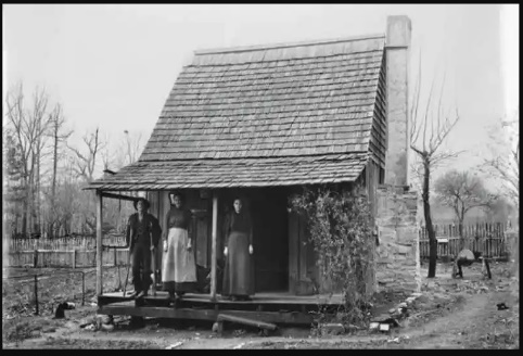
Big Fork Post Office and Hotel
I wanted to know when the Post Office delivered mail on the trail, and when our local Bayou Chapter (BCOS) group worked on the trail, as had been told to me more than 30 years earlier. Initial inquires among BCOS members yielded no information on either question, so I resorted to internet search, which likewise yielded virtually no information. But my initial search did eventually lead me to connect with David Samuel. David is a retired Forest Ranger who now lives in Joplin, Arkansas. He is the person who was responsible for funding and overseeing building of the Little Missouri Falls Trail, restoration of the ABF Trail, and eventual formation of the Eagle Rock Loop. I met him at his home in January, 2023, and we discovered we shared an interest in knowing more about postal service on the ABF. We decided to conduct our own search to answer the question. We spent most of a year perusing library data bases, reviewing Post Office archives, searching for and consulting old maps, reading genealogical records, reviewing governmental records (such as U.S. Census data from the 1800s and old local County mine claims), reading published articles by professionals/academicians about local and area history and folklore, and interviewing residents of both the Athens and Big Fork communities. Our efforts raised unexpected questions, led us to unexpected topics, and yielded more breadth and depth of information that we had expected. From this trove of information, a story of the ABF began to emerge. Although a bit sketchy, David and I view that story as a glimpse of several themes or defining features in the history of west central Arkansas during the past several hundred years.
Origins of the ABF Trail
There is at least a portion of the ABF that is undoubtedly Native American in origin (or was perhaps a game trail that was later used by Native Americans.) This assertion is supported by discovery of a Caddo Indian novaculite quarry immediately off the ABF. This site has been examined and verified as an old Indian quarry by a Forest Service Archaeologist, in consultation with other (non-governmental) experts. Novaculite is a microcrystalline sedimentary rock that is infused with quartz. It naturally occurs on ridge lines and other outcroppings, as well as surface boulders. Consequently, it was easily accessible and typically quarried, rather than mined out of the ground. It was used by Caddo Indians to make cutting tools and weapons, and was desired because the quartz was durable and would maintain a sharp edge. Historians and archaeologists believe the Caddo people used novaculite from around 1400 to about 1600 or so. Based on this time frame, one can infer that at least this portion of the ABF existed around 350-400 years ago, at a minimum. I don’t know if it’s possible to date this particular site any more precisely. It is uncertain how the trail came to be fully constructed. It may have been built entirely by Native Americans. It is also possible that a portion of the ABF is of Native American origin, while other segments of the trail emerged from activities of non-Native inhabitants, especially mining and logging.
Mining and Logging on the ABF: 1800s to Early 1900s
Arkansas became a Territory in 1819, opening the door for westward expansion of settlers. That expansion was aided and accelerated by the Indian Removal Act of 1830. In the contiguous areas around the ABF, primary economic activities of settlers from early to late 1800s included farming, mining, and logging. Some of these endeavors occurred on the ABF. Prospectors would mine for coal, bauxite, zinc, sulfur, and manganese. Mining operations in this area were often relatively small, and some may have been established for personal use only (such as coal). The community of Langley (8 miles east of Athens on Hwy 84) was established mainly to serve local mining camps. (Langley was originally called Lindon. The name was changed in 1883.) It eventually boasted a school, grist mill, cotton gin, livery, and several general/dry goods stores. The current day community of Galena (southwest of Umpire) was a mining camp. On the ABF, the Lost Hatchet Mine operated on the north face of Missouri Mountain, which is the first mountain one crosses on the ABF when coming from the north trailhead. Mining was common throughout much of Arkansas. During the late 1800s, large scale mines in other parts of Arkansas helped pull the State out of its post-Civil War economic slump.
We also found evidence of logging on and near the ABF. Mrs. Cheryl Edwards, a native and resident of Big Fork, told me her father would go over Missouri Mountain most mornings to fell and harvest trees. After trimming, the tree would be drug by mule back to Big Fork, then sold and transported to a nearby sawmill. Mr. Seldon Parsons lives just off of Hwy 246, about three miles north of Athens. His grandfather was one of the early settlers in the area. The Parson family was friends with the Bard family, for whom the (now closed) Bard Springs Campground was named. Mr. Parsons recalls there was a small tram at or near the south ABF trailhead that would carry trees toward what is now Shady Lake Rd. (the old entrance to Shady Lake Campground). The tram traveled behind where chicken houses now sit at the intersection of this road with Hwy 246, then cross over 246 and end near Hwy 84 (closer to Union). There the trees were loaded on to trucks and sent to a sawmill in Dierks. Small scale logging on or near the ABF by settlers and direct descendants probably continued until early 1900s.